
Home
Introduction to Kaho'olawe
PowerPoint
Introduction
Kaho'olawe Surveyor Software
Development Team
Role Cards
Key Elements for Reinhabiting the
Island
Presentation
Assessment
Related readings:
|
The Surveyor software is in a zipped format. Download the zipped files and extract into one folder on your hard drive. Then run the Surveyor.exe program. SYSTEM REQUIREMENTS:
INSTALLATION:
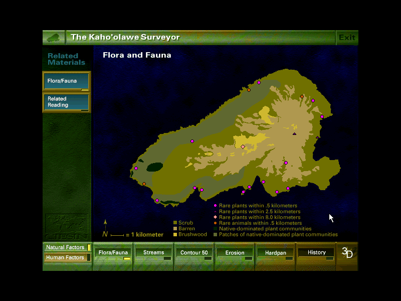 USING THE KAHO`OLAWE SURVEYOR: On the lower left corner of the screen there are two buttons: "Natural Features" and "Human Features." You can view only one set of features at a time. The screen starts up automatically with "Natural Features" selected. When using "Natural Features" you have a choice of viewing maps of the island's flora and fauna, streams, erosion, 50-meter contour lines, and hardpan. When "Human Features" is selected your choice of maps changes to development areas, roads and trails, archeological sites, place names, and safety and swept areas. The "History" button, on the far right, is available whether you have selected "Natural" or "Human Features." For each selection you make you may get a set of viewing options which will appear as new buttons on the left panel. You may also get a "Related Reading" button which offers more in-depth discussion of issues related to the features you observe in a given map. When you click this button, a page of text replaces the map you were observing. Use the left panel buttons to return to your map. When you click the "3D" button in the lower right corner the island flips from a "2D", top-view, to a view of the island as seen from a perspective 23 degrees above the horizontal plane. This viewing angle is depicted in the left panel in the upper left window, which opens when you click on the "3D" button. You can use your mouse to click on the arrows on the left panel to rotate your view of the island, or use the arrow keys on your keyboard. When you want to return to the maps described above, click on the "2D" button in the lower right corner. The island will flip back to its "2D" perspective and the buttons along the bottom of the screen will become visible again. To exit the Surveyor, click the "EXIT" button on the top right corner of the screen. This button is somewhat temperamental, try to get your mouse in the top right of the Exit button. Just keep clicking around the button if it doesn't work the first time. |