This website describes a digital history project I have been working on and off for the past few years. It originally started with an attempt to answer a simple question, but over time it has developed into a full-fledged investigation that leverages multiple online resources. Because of this, it is an excellent example of digital forensics, or how different online sources can be investigated and cross-referenced for evidence. I hope you enjoy this site, but as you review it bear in mind that it's most definitely UNDER CONSTRUCTION. If you are so inclined, e-mail at the address below to let me know what you think (or to contribute articles or ideas).
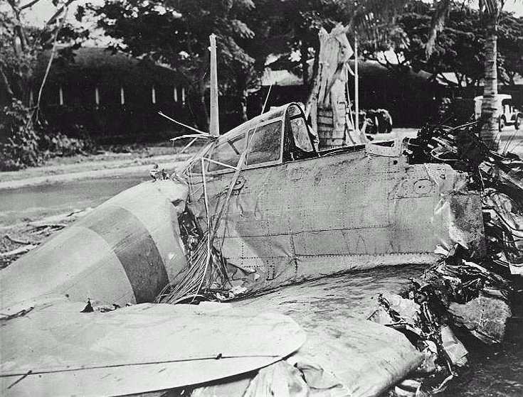 On December 7th, 1941, a Japanese Mitsubishi Type 0 (“Zero”) crashed on the site of what was then part of the US Army Coast Artillery post of Fort Kamehameha. This US Navy photograph of the crashed Zero shown to the left is one of the better known images of the attack and appears in many books and online documents. These sources identify the crash site as "Building 52" or a machine shop.1
Today, many of the original buildings on the site of the fort have been demolished, and there is currently no Building 52. The only WWII-era structures remaining are the old officer's quarters, which are still in use. During the mid-1970s, my family lived at Fort Kamehameha (“Fort Kam” as it was known) in Quarters 4. These houses began at the east end of the Fort and were numbered sequentially along Worchester Road, the main street. Curiously, the first house was Quarters 2. Legend among the residents was that Quarters 1 had been destroyed on December 7th. The photo of the Kam Zero, with buildings that looked much like the officers quarters in the background, lent credence to this legend. A few years ago, the question of where the Zero crashed and what happened to the plane and it's pilot were raised again. Using mostly online resources, I commenced to find out.
On December 7th, 1941, a Japanese Mitsubishi Type 0 (“Zero”) crashed on the site of what was then part of the US Army Coast Artillery post of Fort Kamehameha. This US Navy photograph of the crashed Zero shown to the left is one of the better known images of the attack and appears in many books and online documents. These sources identify the crash site as "Building 52" or a machine shop.1
Today, many of the original buildings on the site of the fort have been demolished, and there is currently no Building 52. The only WWII-era structures remaining are the old officer's quarters, which are still in use. During the mid-1970s, my family lived at Fort Kamehameha (“Fort Kam” as it was known) in Quarters 4. These houses began at the east end of the Fort and were numbered sequentially along Worchester Road, the main street. Curiously, the first house was Quarters 2. Legend among the residents was that Quarters 1 had been destroyed on December 7th. The photo of the Kam Zero, with buildings that looked much like the officers quarters in the background, lent credence to this legend. A few years ago, the question of where the Zero crashed and what happened to the plane and it's pilot were raised again. Using mostly online resources, I commenced to find out.
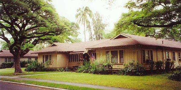 The photo to the right is a typical set of officer's quarters. These were constructed around 1915 for the families of the officers assigned to the Coast Artillery regiments billeted at Fort Kam. If one looks at the Kam Zero picture, one will see that the rooflines and window arrangements of the buildings across the street from the crash site are very similar to those of this house. This similarity provided some evidence to support the claim that the Kam Zero crashed into Quarters #1. A description of this style of quarters can be found in the Historic Military Quarters Handbook.
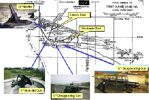
The first step in the internet investigation was to determine what Fort Kam looked like in the 1940s. Google searches eventually turned up a 1922 survey of all the coastal defenses of the United States and territories, including Hawaii. The map above, from that survey, shows the shoreline, batteries, and major roads of Fort Kam when it was the largest of a group of forts that protected the island of Oahu and was home to three regiments of Coast Artillery. Note the long east-west road, now named Worchester Road, and the north-south road, now named Seaman Road. Fort Kam featured a number of large and medium caliber gun emplacements, or batteries. Four of these, Batteries Hasbrouck, Selfridge, Jackson, and Hawkins, were grouped in the western half of the fort near the enlisted barracks and officers quarters. The photographs on the map show examples of the type of guns that were mounted at these batteries. While the guns were removed long ago, the concrete batteries are still in place and would provide important landmarks for determining locations of old structures.
1 http://www.history.navy.mil/photos/events/wwii-pac/pearlhbr/ph-ja3.htm